Tuesday, May 23, 2023

Lovely Twin Peaks

Okay, so I wrote this up and then gave it the title...and now it's making me giggle. Sorry - I always have my mind in the gutter. Anyway...yes, the word lovely. Here's its definition:

        1) Charmingly or exquisitely beautiful

        2) Having a beauty that appeals to the heart

        3) Delightful, highly pleasing 

It's not an adjective I use much, maybe never while hiking. The mountains are "amazing" or "breathtaking"...but lovely? That's a word that describes a different sort of chord. But as we hiked the hills of the Twin Peaks trail, we must have said "lovely" a dozen times. Those heart strings that appeal to "delight" and "charm" were being plucked in way that no other hike has. It was a wild flower fantasy come to life. 

And though 95% of the folks on the trail with us were on bikes, every single one of us had the cheesiest grin that shined out like a kid whose lap is full of puppies. Though Heidi and I felt a little like trespassers - invading what was clearly a biker's heaven that us hikers have never heard of. But everyone was so kind and cheerful, I mean, this was the best day ever! As one lady passed us on her bike, she explained that her husband was probably wondering what was taking her so long. "I'll just tell him I was going the speed of flowers," she said with the same ear to ear grin we were all wearing.

Can't stop smiling!
You can never have too many flowers, but you can have too much sun. Poor Heidi hit a wall with nausea and dizziness after we pushed up a very steep short cut to try and get to the mountain view another biker had told us about. 

Steep is always hard - but better with flowers :)
This is why I will continue to advise people to use a hiking umbrella. It is so multi-purpose: saves you from rain, hail, sun, and also works great as a peeing shield. Yep, you know how you haven't seen anyone for at least an hour, but as soon as the pants are down...I swear it's a law. (Murphy's, actually.) Heidi wasn't hiding behind any sort of tree; in fact, she was perched up above the trail on full display - like a monument to urination. But, I had her back (or butt in this case) and ran over with my umbrella to save the day. The biker coming through found it quite amusing.

This looks like a good place to pee, haha
I'm coming Heidi! ;)
Speaking of the bikers, the one who gave us directions up to the mountain view also told us not to worry too much about the plethora of intersecting trails because the main "road" is always the "truth" to getting down. That may be true, but according to Heidi's map app she had blessedly downloaded, it was not taking us down to where our car was. Trying to decide from the assortment of trails that would help get us there, we decided "Prepare to Die" was the best choice. What is wrong with us?


As soon as there was a different trail we could veer off on that didn't involve a biker's death wish, we quickly did so before one came through and landed on our heads. Maybe there are rules about "bikers only" areas we were unaware of?


We finally made it back to our car, thankfully without wasting too much time being lost; which was very important because we still had a two hour drive to where we planned to backpack for the night. I'll tell you about that next time; until then, Happy "lovely and death free" trails! 

THINGS TO KNOW ABOUT TWIN PEAKS:

1) Bring a good map or reliable app - unless you are prepared to die, because you could be out there for days. And they are building even more trails!

2) Bring a 4-wheel drive. The bad section of road to the trail head isn't long, but you'll be glad you have one.

3) Don't wear head phones and pay close attention to where the bikers are, then get out the their way quickly. This is clearly their turf.

4) Heat exhaustion is real, and heat stroke can be deadly. Bring lots of water and if you start feeling nauseous or dizzy, find shade and take a break with food and water. (Which we did and Heidi was all good to go.) I know I fared better because of my umbrella, so seriously think about using one! (Plus they make for a cute picture!!)

BONUS THING TO KNOW:

If you want to see some wildflowers but don't feel like driving any further than Leavenworth, there is a strange little "trail" (abandoned road, really) just off Hwy 2 between milepost 92 and 93 called "Tumwater Botanical Area." In my mind, "Botanical Area" means "gardens" but this is most certainly not the case. Don't get your hopes up for anything too "lovely" - though you will see flowers and get a decent work out in. Or you can just go a half mile up and back down like us ;)


Thursday, April 20, 2023

Bit by Bit -- and Thankfully We Didn't Get Bit


It was a lot work for a measly 2.6 miles; but my total for Pacific Northwest Trail miles is now up to 321. My arbitrary ambition of completing 500 miles on 5 different long trails is just an excuse to get out there - so I'm not complaining. It motivates me to zone in and research any trails to help with the goal. (I started this old blog when I wanted to do 500 on the AT, and then I just needed something else to do.) How fun it's been, because I know so many of these places I NEVER would have seen otherwise. 

Though the miles we just did only to get to the PNT, I actually very well may have done. I was hoping to do them back in 2019 to see the abandoned Ranger Station (story here ) but ended up stopping way short at the Elkhorn camp. (Which is now closed, btw. I don't know why or for how long. Sad, it was a nice place.)


When I called the actual Ranger Station in Quilcene this time around to try and get the low down on the snow situation, he called it a "slog," with the implicated question of "why would anyone want to do the Dosewallips River Road?"  Yes, it is just an old forest road gone bad, and yes, it can therefore get monotonous...but it has it's charms. Most importantly though, it is accessible in April - and it leads to the PNT. With a few days off work, it was my hiking buddy, Janet, who inspired this trip - and you know I didn't need any arm twisting; even though these early season trips can be pretty iffy. (Like last year's trip here.) 


Speaking of iffy, and if you are wondering what's up with my title, I shall now expound. Once we were finally 10 miles in and finally on the actual PNT, we started noticing these strange markings on the trail.


Our joking about a one legged monster elk aside, we had to wonder if someone was preceding us and leaving them for reasons unknown. But then we would hit the snow patches without a trace of anyone or anything that had gone across. Then as we went further in and hit dry trail again, there the mark would appear again. Over and over, maybe every 500 feet or so. Weird, right?

We finally had to turn around after only going those piddley 2.6 miles - I was really hoping to push hard and get as close as I could to the Grey Wolf intersection where I had come in two years ago (Grand Loop story here ) but the snow eventually won.


My specific trail log is below like always, but I'll end here with the answer I got once I got home and posted my mysterious trail mark pics on my favorite hiking forum-

From "Hesman": My guess is cougar territory markings. From what I have read, they will urinate and then cover up the urine with a small pile of duff.

Eek. Well, thank you, kitty, for letting us pass through; even though you were so veraciously letting us know it was your turf. Next time I see your signals, I think I'll turn around sooner. Until then, happy "no puncture wounds to the neck" trails. ;) 


TRAIL LOG:
Day 1: We met at the trailhead, which is conveniently located between Janet's home of Portland and mine in Skagit Valley. It's not a bad or long forest road, and there is sort of a parking area just before the huge washout/beginning of hike - though expect to have to park along the road, because it is popular. You "slog" up, with the only steep section right where the falls are - at around 5 miles in. My guess is cars would stop to take pics, explaining the old sign that made us laugh. 
Just beyond the abandoned Ranger Station at 6.5 miles, you will start on "real" trail. There is a confusing spot here, where a sign mentions a Terrace Trail Loop. Go right -- it does not look like there is a trail AT ALL because of a blow down. We went left on the "loop" and that trail SUCKS. It does eventually lead back to the main trail, but if you just go over that nasty blow down, you'll avoid that stupid loop part. 
Go this way


After 2.5 miles, you'll hit the Y that either goes left to eventually bring you to Enchanted Valley, or right towards Hayden Pass. We went left, but only to get us to the Dose Forks Camp at 8.5 total for the day, where we had a permit to stay. REALLY nice camp, and we had the whole place to ourselves.
SO ready to get this dang duro log out of my pack!

 
But SO worth it!


Day 2: Left camp and "slackpacked" back up to the Y, this time heading towards the PNT intersection, which you hit after a mile - mostly up. The grade after that is pretty gradual, but as mentioned, eventually got us up above the snowline. Pretty trail though, with one very beautiful waterfall. We got back to camp around 3:30, after an up and back total of 8 miles. 
Finally on the PNT


Day 3: Slogged the 8.5 miles back to the car, which was not as much fun in the rain. But a stop at Quilbilly's in Quilcene is a great way to dry out and warm up. Highly recommended!
A moody day out

A wet visit to the old Ranger Station
A good beer makes everything better 


Sunday, February 26, 2023

Rich Ladies Hike Gone Bad

First of all, we are not rich ladies...though it is hard not to feel a little fat-cat if you are headed to Avalon on Catalina Island. A vacation destination extraordinaire, the small town of Avalon offers resorts, tours, fancy dining and upscale shopping for those who can afford it. But for us not so well-to-do gals, it was a just a place to walk through in the setting sun so we could start hiking the Trans-Catalina trail in earnest come morning light. 


I decided to call this post "The Rich Ladies Hike" on day two - after our second night at a campground with running water, picnic tables and nice pit toilets. There were even signs touting services that offer to bring your gear to every camp spot along the way if you didn't feel up to hauling a pack. This was certainly a far cry from our usual "cat hole" experience, and the fact we did have to pay a fair amount of money just to get there (plane tickets and boat rides and permit costs add up) all contributed to the idea that this adventure was only for the more privileged. 


We lucked out and ran into the famous Bison herd! 
Google it if you don't know.

And we sure felt privileged as we ate our fancy lunch in the sun at our stop along the way at the "Airport in the Sky"...this was living the high life indeed! But money can't buy you everything. It may get a heavy pack to the beautiful "Little Harbor" campground for you, but it ain't gonna stop the wind.


Calm before the storm

From now on, I will take a "high wind advisory" more seriously. I did do my best to prepare by using my guy lines and trying to stake down everything nice and tight...maybe too tight? My stakes didn't come out, after all - the ties actually broke! Along with one of my stakes...right in half! It was pure disaster. I will forever be indebted to Dani, who let me crawl into her tent in the middle of the night. Beth on the other hand didn't try to fight it, and just let her tent become a bivy bag. All I can say is thank God it didn't rain too, because we would have been screwed. 

More like body bag than bivy bag

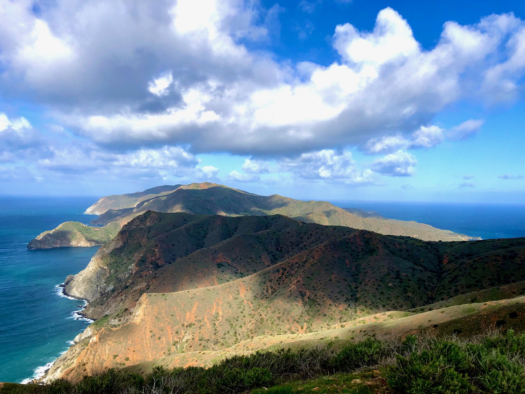
Windy, but beautiful

The "made it to the top" selfie

Wondering how I was going to set up a tent on our fourth night with snapped lines and missing stakes as I fought to stay upright against the wind on the astoundingly exposed cliffs leading to Two Harbors, I at last staggered into town only to find my posse already cozied in at the Catalina Cabins. Turns out two deck rooms were provided to us for free because of the unsafe conditions predicted at camp by another upcoming storm. Sometimes it's better to be lucky than rich; so even though we were told our adventure had to come to an end the next morning, we still felt quite fortunate to be getting out of there alive and well. And considering ferry service was predicted to be closed for possibly another week due to the weather conditions, we felt extra blessed to be making this timely departure.

I have to admit, I am a little bummed to still be a "non-thru hiker." Guess I'll have to squirrel away my extra cash until I can afford another go. Until then, happy "rich with laughter, friends, and luck" trails! (Daily itinerary below for those interested. Also I did go back and finish...story here.) 


Day 1: A last minute ferry change because Beth's flight got delayed at the eleventh hour ("why did she fly Delta?" was Dani's first response) got us to the island at sunset. We were grateful for the easy 1.5 miles to the Hermit Gulch Campground.
What a bunch of tourists, haha


Day 2: Even at only 62 degrees, I was very overheated getting into the Black Jack Campground after 9.5 tough miles. Shade is pretty much non-existant on this entire trail. And yes, of course we played Black Jack at camp!
A local legend- Greg Stumps


Day 3: Eight miles to Little Harbor, with the stop at the airport about half way. Probably my favorite day...until the wind storm of course.
I loved the moody feel of the ridge walk

Day 4: Five miles to Two Harbors, but don't be fooled. Really tough miles, but stunning views that keep you going.
Two Harbors is cute! And it has booze, haha. 
Order the "Buffalo's Milk"...it does not disappoint.


Day 5: An easy up and back on the road portion of the trail that leads to Parson's Landing, where we were supposed to camp that night. Instead we did three miles and had to turn around to get back in time to catch the one and only ferry leaving that day. Otherwise we would have done the 6.5 miles to Parson's Landing to camp, then taken the "rough portion" on the other side of the loop leading back to Twin Harbors, which totals eight miles. FYI, that part of the trail closes when it rains because the mud is slick as snot and the trail steep and treacherous, so we couldn't have finished the trail even if the ferries where running the next day. 


Monday, February 13, 2023

High Steel Bridge Blessings

The Instagram real from @explorewashstate showing a dizzying aerial view of Washington State's highest bridge had me memorized. A 375 tall steel bridge you could walk across with a stunning vista of river and waterfalls within a few hours drive from me? Count me in!

Though those few hours included getting through the agony of the Seattle/Tacoma 1-5 traffic hell...which is a lot to endure for a 685 foot stroll. Being that I really wanted a test run with my new backpacking tent, I searched for early season hikes in the area to make it worth it.

Eureka! The Lower South Fork Skokomish River was close by and looked perfect for an easy backpack; but being I had that traffic gauntlet to get through on a late Friday afternoon with daylight fading soon after 5 pm, I needed something easier than easy. 

Julie must decorate...it's tradition :)
Eureka again! Brown Creek Campground is right between the bridge and the hike - and six sites are actually open year round! February adventure, here we come! (We-- meaning Julie and I. She is crazy enough to be game for my stupid ideas, even after the Boundary Trail !)

Though my hiking addiction does cause me to make some questionable decisions, I have always been blessed with such incredible good fortune. We narrowly avoided some sure to be horrendous freeway backups, had clear skies with twinkling stars smiling upon us, arrived first at the trail head with more good weather, then barley even had a slow down all the way back to Skagit Valley. May you also find your early season fixes with just as much good luck. Happy trails! (Things to know list below as usual.)

Things to know for the Lower South Fork Skokomish River Trail and High Steel Bridge:

1) The road is not bad BUT make sure it's passable before you go, as rock slides and flooding are concerns. And do try to get there early -- the lot was full by mid afternoon IN FEBRUARY.

2) Make sure to download directions to BOTH places -- very confusing forest roads to the bridge, and service ends about 8 miles before the trailhead. But there is service on the bridge! We were thankful, because we found the directions to get home brought us over the bridge (you can drive on it) and it was a much easier and shorter way out.

3) If you want to car camp at Brown Creek, try to do Friday/Saturday if possible instead of a Sat/Sun. I was shocked to see 5 out of the 6 spots taken when we drove by on our way out on Saturday at around 2:30. Guess there are plenty of idiots who want to freeze their asses off in February. ;)

4) We enjoyed the Taqueria Las Palmas in Shelton. Nice, but not so nice that a stinky hiker would feel awkward. 

Cheers to being lucky hiking idiots!