Sunday, July 24, 2022

Hiking with the Big Dogs

When asked my greatest fear just before leaving for my 50 days on the Appalachian Trail four years ago, I kind of surprised myself by answering "not fitting in with the thru hikers." What a dumb fear when you could get mauled by a bear, right? But I admire so much anyone who has the immense strength and stamina it takes to complete a 1000+ mile trail, and therefore am quite intimidated by them. 

So imagine my trepidation when finding out I needed to keep up with three former thru hikers on a quick 6 mile round trip support hike I had volunteered for through the PNT website.Ugh.

I confess my motives for coming were more than just charitable - I was excited to get an extra 3 miles toward my 500 mile goal on the PNT while feeling good about helping at the same time. All I needed to do was haul in some food supplies - easy peasy. (To toot my own horn I will say I have given money to the PNTA...I do REALLY appreciate all they do.) 

First of all, getting to Elbow Lake is just accessing the PNT, so my current number of 260 miles stays the same. Secondly, knowing these are very strong backpackers who could have easily split the weight I carried and still make it up quicker than having me come along did not make me feel much like a "helper." But I like to think I made their day more enjoyable by not having so much weight and having the excuse of going slow. 

I know they made my day more enjoyable. I had to face one of my other greatest fears of log crossings (double ugh) and this one really did freak me out. I don't think I would have gone across if not for my need to save face with the Big Dogs and for the fact one of them ferried my pack across for me. 

But the best part about hiking with thru hikers is getting to hear their stories, and I heard some doozies. I'd tell you the one that ended with "I've never been so relieved to see a big hairy penis"...but I'll let you wonder. That kind of disclosure is only for those who can hang with the Big Dogs. ;) Happy "facing your fears" trails!

To donate or volunteer or just to find out more click here

Trail Info:

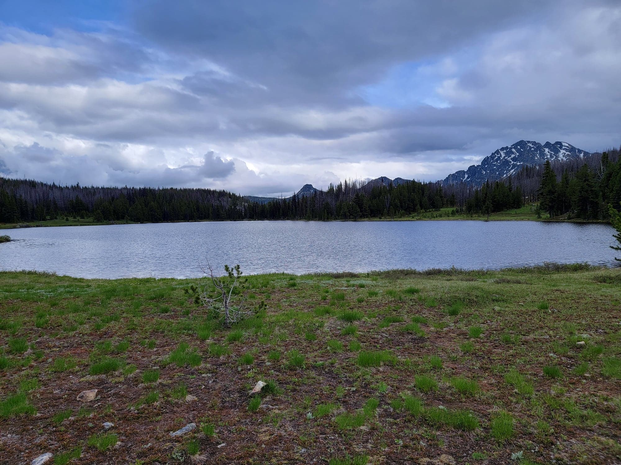
If you look up Elbow Lake it will tell you it's inaccessible, but that is only if you are coming in from Mount Baker Hwy. The entrance from Mosquito Lake Road is fine if you have a high clearance vehicle. You will also see a round trip mileage of 16 miles, which must be from the other entrance as well. The forest road you travel for the option I did is about 11 miles if you stop at the first parking area you come to, and you'll see the trail directly across the road. (No signage though...and as mentioned earlier, it's a 6 mile round trip to the lake.) The river cross is probably less than a quarter mile bushwhack downstream, though I'm guessing later in the season it won't be needed. I'm assuming the 2,000 foot gain mentioned is from the other access point, though it did feel close to that. Whatever it is, it felt like a workout for sure. If you are super hungry like I was, take a right instead of a left at Mosquito Lake road on your way out and find yourself at the Welcome mini mart store which offers great burgers and a nice outside eating area. 

Decent camping if you are so inclined...just be sure there is not
a trail crew there taking up all the spots before you go ;)


Friday, July 8, 2022

Type A, B, and C "Fun" on the Boundary Trail


While scanning every early July trip report for the Boundary Trail on my favorite Washington Trail Association website, I found a story where a dad described having lots of both "type A and type B fun" with his family. It made me laugh, because I knew exactly what he meant. We all hike for the "type A" experience...amazing views, being in nature, bonding with our loved ones, getting off grid. But we also know to expect "type B"...bugs, bad weather, blisters, aching muscles...the hard stuff. I loved that this Dad put the positive spin and labeled them both as "fun" because it's all part of the adventure. We may not actually like type B at the time, but when we come away, we always realize that the whole package is what made the trip meaningful.

But after experiencing a piece of the Boundary Trail for myself (another 31.4 miles checked off towards my 500 mile goal on the PNT) and thinking about how I was going to tell my tale, I decided I needed to add "type C fun" -- which is the danger/fear aspect of hiking. It is part of the package as well, and no matter how much we plan and prepare, there is risk to hiking. But risk = excitement, right? I know there is a part of me that craves it, even though it really does not feel good in the moment. Though this trip humbled me. A little too much type C for my liking.

The deal with risk is it is only fun if you win the gamble. And while the fear you are feeling when you are wondering if you are going to lose may produce a lot of adrenaline, (and therefore has an aspect of "fun") the guilt you would feel if you actually lost, ESPECIALLY with someone else's health or even life...well, that would be no fun at all. In fact, I don't know how I would live with that kind of guilt. 

I'll give the full trip details below, but there was a moment after we climbed down a talus slope and finally felt out of danger where I totally broke down. We sat down together on a rock and I laid my head on Julie's shoulder. With tears I simply said, "I'm so sorry." I felt like I had researched this hike enough, but I knew I was pushing the envelope with early July and the heavy snow pack we've had this year. Thankfully, we won the gamble and made it out safe and sound; and even with all our type B and C experiences, type A made it all worth it. Julie even told me she'd do it all again. I'm so very grateful. Happy SAFE trails, with mostly type A fun. 

Love you, Julie

Trail Log:
DAY ONE: 5-ish miles to a wide enough spot in the trail to place a tent. We had crashed my friend's campsite on East Chewuch River Road the night before so we could get to the start of our hike around noon. How lucky am I to know Anita, someone who loves remote camping and will drive forest roads just for fun? So in the morning we drove together to drop my car at our Andrew's Creek Trailhead end point (great parking and toilet,btw) and then all piled in their car (grandchild between us in the back seat and dog in the back) to our Cold Springs Campground starting point. You can drive the 3 hour long way around, or you can cut across on some crazy ass forest roads. (A little type C fun!) I will say here that if you decide to enter the Pasayten Wilderness via this trail, you had better have some kind of navigational app, because in some spots there really is no trail. (I think this is mostly used as a snow mobile trail, so there are diamond trail markers on trees...see pic below) After about 3,000 feet elevation gain and quite a few blowdowns, we just came to a stop somewhere between the Pasayten boundary marker and Goodenough Peak. Not the plan, but that was okay. I've learned to let go of plans. I should have loaded up more on water though to accommodate plan changes...that is a lesson I am having a hard time learning. But it was a really great night nonetheless. 


We're off!

Trail? See diamond on tree in distance

Let the type B fun begin!


Getting my PNT miles in, baby!


Let's just stop right here

DAY TWO: 7.4 miles to Fireplace Camp. Again, not the plan, but the blowdowns were ridiculous!! We were fine until somewhere past Coyote Camp (these names are off the Guthooks App, I'm not sure if you'll find them anywhere else) in fact, we had a glorious lunch in the Horseshoe Basin area with a well earned sun break. But then type B hit...thunder storms and then entering an area that looked like a war zone. It must have taken us at least an hour to go a half mile over all kinds of blowdowns. We were so thankful for the lovely camping area by a still full tarn (no fireplace though...I have no idea why it has that name) and we didn't hesitate to call it a day. 

Lunch and sun at Horseshoe is type A for sure


Getting over blowdowns with an umbrella is a challenge

Type B fun just keeps getting better!

DAY THREE: 6.8 miles to un-named camp just before Scheelite Pass. Guess what...this was not the plan! Ha ha, we were just taking it day to day at this point. The rain was starting to come on again, and the nice fire ring and tree cover at this spot were calling our names. We were in our tents by 2 pm! But thank God, because the rain really hit hard. First time I've had an epic fail with my tent...everything got wet. As soon as we had a break from the rain, Julie helped me move my tent out of the puddle. A very type B night. I've decided I need to have a zip-lock with an "emergency" light weight set of base layer clothes. Lessons learned--thankfully we had sun the next day, so not too painful a lesson. Oh, and we saw our only other humans this day: a couple and their dog going the opposite direction. We let them know about the upcoming tree obstacle course, and they told us Cathedral Pass was "not as bad as we expected." I really should have asked them their definition of bad.

Such a nice fire pit...too bad the fire went out in 5 minutes

DAY FOUR: 7.4 miles to Cathedral Pass. This was the best day. The type A stuff that makes you forget everything else. We crossed several small snow patches, taking the "you look so bad ass" pictures, agreeing that indeed, this wasn't so bad. Then we started to switchback up, and holy hell. WTF! I really started to panic, and actually thought for a moment we would have to turn around and go back the way we came. (Eventually calling someone to come get us, which would have pissed that someone off for sure.) But I kept thinking that somehow that other couple had made it. Then it hit me...we don't have to follow the trail. Just go up the gap where there isn't snow. Type C fun over. We won the gamble and camped in the most beautiful spot and basked in all the type A glory.

The Old Tungsten Mine is really cool!

With lots of type A opportunities 

Feeling like badasses


Wait a second...we've slipped into type C

A different way up

Such a beautiful place to spend the night...
extra points if you can find my tent!


DAY FIVE: 3.6 miles to Spanish Camp. Julie is not going to believe reading it wasn't even 4 miles, because it felt like 10. (Well, officially from Guthooks math it's 3.6 miles. We certainly did more with our detours.) We struggled finding the trail down with all the snow, but with our apps and maps, slowly made our way to Upper Cathedral Lake. I really thought we were home free. Then I saw it. I don't think I've ever had such a sickening feeling in my stomach. The stretch of snow going across a very sheer face of rock looked absolutely treacherous. I didn't pack my crampons. I was going to, but in all my reading I didn't come across any strong warnings that the snow crossings could be this bad in July. (Even in a heavy snow year like this one. I mean, I expected deep snow in places...but not dangerous drop offs.) Honestly though, even with crampons (which Julie did have) neither of us wanted to go across it. I felt sick...I mean SICK. There was no "we will just turn around and go back" thoughts; only a realization that we needed to risk it, or figure out a way around it. I mean, people do go over this shit...that couple and their dog had to of, right? But maybe in the three days since they did it had changed a lot? I don't know--I'm still baffled by it. We both looked down, and decided that even though the talus field also looked treacherous, it was preferable to the snow cross. It was REALLY hard (having to take our packs off at times and lower them down) and certainly not safe (who knows if these rocks will actually shift?) but we made it down. After our emotional moment at the bottom, we climbed our way back up to the trail on the other side where it was mostly snow free. Once we made it to Spanish Camp and recovered in some sun, we added another 5-ish mile round trip to Remmel Lake...so around a 10 mile day total after all. Oh, and one more story for fun. I had used my tiny Swiss Army Knife scissors to open some cheese as I was snacking in my sleeping bag before bed. An hour later, and almost asleep, I rolled over and felt something pierce my leg that I could only imagine was a spider of epic proportions. I scared Julie half to death with my screams, only to find my scissors still opened in my sleeping bag. I must of just set it down next to me with my totally fogged out brain. I should not use anything sharp when I'm that exhausted!  

Cathedral Lake


Fuck no
Julie almost done with the talus slope type C fun

Back to type A!!

With a warning that type C could be lurking

Spanish Camp did not disappoint
Remmel Lake with Remmel Mountain 


And a tent view is always type A

DAY SIX: 15.5 miles to the car. (Not PNT miles, btw) We were prepared to take two days to get out on the Andrew's Creek Trail, because we weren't certain if it was going to be cleared of the blowdowns by the time we got there, and I had read they were really bad. Thank God it had been cleared, because after seeing the remains of the mess, I seriously don't think we could have gotten out if they hadn't. Even so, this is the worst trail I've ever been on. SO muddy and overgrown--a total slog. The WTA website states this as a 31 mile round trip hike, and I made the mistake of rounding down and telling Julie 15 miles. (NEVER ROUND DOWN!!!) When her GPS multisport watch clocked in at 16 miles and we still had a mile left...well, if you know the last mile blues, then you know. We were in the HEIGHT of type B -- soaked and exhausted and OVER IT. Plus Julie was really stressed about the creek ford that she had read could be really bad at the end of the day with snow melt and heavy rain.(And the "creek" we were paralleling all day did look more like a deadly river...turns out that is not the creek you cross at all!) After we crossed the actual normal looking creek, Julie turned to me and said, "All that stress for nothing." (Why anyone warned about that cross I do not understand.) Driving out we saw there had been a MASSIVE washout on East Chewuch River Road that had thankfully been cleared enough to drive through safely. Dangers and risks are everywhere, even when we don't go looking for them. But I'm going to try and steer clear from them as much as possible from now on -- I promise!


Andrew's Creek had type A moments

Remember to close the gate!

But soon became a hard type B

We didn't want to have to cross Andrew's Creek

And thankfully we didn't have to! The water wasn't even cold!


Done! I said "look as miserable as possible for the pic"
and then we said in unison, "that shouldn't be hard"


But she forgives me...
though maybe next time she should plan the trip ;)