Monday, May 26, 2025

The Ever Changing Quest for a Memorial Day Weekend Plan

Memorial Day weekend could be considered the kick off to the summer backpacking season. Problem is, it's not even June yet, and so options are quite limited here in the PNW. 

We had been trying to come up with a plan since February. Plan A: Carbon River to Ipsut Falls...then the Fairfax bridge failed and wah wah, that one is out indefinitely. Plan B: Desolation Peak. Yes, it's early to attempt it, but I read trip reports of others doing it on Memorial Day; plus I felt we could handle a little snow travel after our successful Cow Heaven outing. Only after getting our permit did I realize this was also a big "wah wah" because the Ross Lake boat taxi is not operational until June. (The TR I had read involving a boat ride must have been a personal boat...the devil is in the details!) Plan C: Iron Bear on the Teanaway Ridge, but that got nixed too because Heidi had a last minute scheduling conflict and couldn't leave until late afternoon on Saturday, plus she also had to work Monday. 

So I had pretty much resigned myself to yard work over the beautiful weekend (biggest wah wah of all!) but then Heidi had read a TR of an Eastern Washington hike that was busting with wildflowers (she is an addict!) and thought we could at least make a day hike out of it. This plan meant Julie could make it too, and it would be great to have the three amigos back together.
But a day hike in Eastern Washington meant driving 2.5 hours to hike for 5-7 hours and then driving another 2.5 hours back. Yes, I've done it before...I don't love it. Maybe we could find a car camp spot somewhere along Hwy 20 on Saturday night? On the best weather Memorial Day weekend we've had in a decade...yeah, that will be easy! (Sarcasm intended.) 
We stopped at every campground along the way, and you guessed it...wah wah. But I had a back up plan. I thought about sharing, but I kind of want to keep this on the down low. But if you are really interested to know, you might be able to figure it out if you read this story.

So after an amazing night of having this "secret" spot all to ourselves (well almost, two guys slept in their car, but we didn't even hear them come in) we got an early start and drove another hour to our destination of Driveway Butte that starts right across from the Klipchuck Campground, our last resort back up plan to camp. But you guessed it again - totally full as well. Thank God for the secret spot!

We'll never tell! ;)

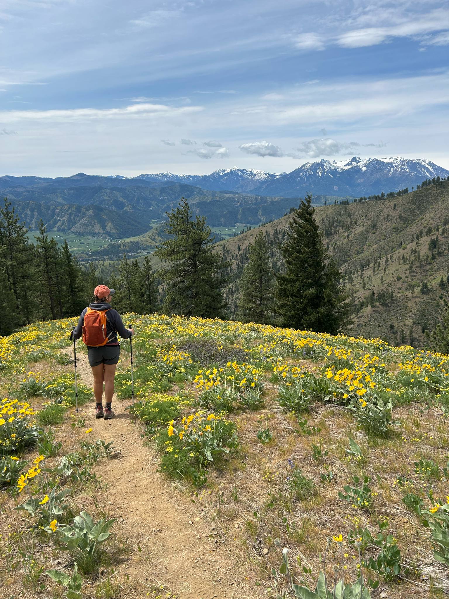
Funny enough, Driveway Butte got it's name because it used to be a "driveway" for herding cows, and we had to once more wonder how the hell these cows made it up these hard ass trails! (See Cow Heaven story.) Actually this trail is kind of like my last two adventures had a baby - massive incline meets massive flower show. 

At the half way mark we had a decision to make. Keep pushing on the official trail to the official view where the fire lookout used to be, or just go about a quarter mile further and turn right on a informal trail that would take us to views that were "nearly as good" (quote from ranger who stopped to talk to us) and save 2 miles and 500 feet in elevation. Well, you know I've always said I'm a hiking cheater ;) Happy "ever changing plans are better than no plans" trails!  
More babies coming soon?

Things to Know:

1) Both the Driveway Butte and the cheater "to the Southeast Viewpoint" can be found on Alltrails. The first option is 8 miles with 3K gain and the second is 6 miles with 2.5K gain. Either one will kick your ass! 

2) I'll quote a review from Alltrails because she said it well: "if you have a low threshold for a fear of heights/vertigo triggers, there is a rather steep, exposed hillside where the trail is thin and sloping as it cuts across". Julie could relate, and she turned around last time she tried this trail. But both Heidi and I tend to push her past her comfort zone...I think she loves us for it ;)

3) The first quarter mile after turning on the unofficial trail is very overgrown, then very exposed. Pants will save the scratches, but then you risk getting overheated. We went with scratches - they weren't too bad.

4) Drive another 15 minutes into Mazama for your burger and beer. There's a new place called Mazama Public House which we really enjoyed. 


Tuesday, May 6, 2025

Thank You, Beautiful Flowers


I've been struggling with wanting to write up this trip report - I've actually been thinking about quitting altogether. When life and it's sorrows come knocking on your door, it's hard not to see this kind of thing as trivial. Why am I doing this? What does it even matter?

Walking in a field of flowers is not going to change the fact that life is hard. But I believe that finding a little joy in a moment of golden light surrounded by blooming glory is what gets me through the everyday grind. I'm sorry that this kind of "Instagram famous" hike can feel like a competition for the best picture. I get it, and I get why people take issue with it.

I don't want to add to the problem. But even though there were too many people and not enough parking, I saw everyone finding joy in the flowers. We need it. And we need to find patience and grace to deal with each other in all our imperfections and self serving ways. (I gratefully paid my parking ticket - I deserved it, but I do maintain it was a safe spot.) 


I'm not going to feel too guilty about this trip report because I doubt it will make a difference in the throngs that are going to go searching for the super bloom. And besides, I am part of the throngs; so judge me as you will. The flowers gifted me their beauty regardless. 

Things to know:

1) Both of these hikes are found in the AllTrails app, so it's not like they are some secret. The first is under "Olalla Canyon Ridge" and it's only about a 3 mile up and back with just 500 ft gain, so it's no wonder it's a madhouse. There is room in the "parking" for like 3 cars, so how can you not expect folks to park along the road? As far as I could tell, this was legal, as there is plenty of shoulder space. I know the locals don't like this, but it's not like you are parking in front of people's houses. I live with tulip traffic in my neck of the woods...it is what it is, and it's only while the flowers are blooming.


2) We stayed at the Leavenworth KOA so we could get to the hike late in the day and avoid some of the crowds. It's tough to pay $50 just to put up a tent, but I will say the bathrooms are exceptional. 

3) We should have left earlier for our second hike of "Cashmere Canyons Preserve" but when you are paying that much to camp you kind of want to stay awhile. This hike's lot has room for about 20 cars, and at 9:30am it was full. There was shoulder room for about 3 cars on either side of the lot, so I squeezed myself in. I felt bad about it, but I swear I would not have done it if I couldn't get my entire car completely off the road. But I agree that I was still naughty, and I got a parking ticket to prove it. 


4) This area has many miles of trails with awesome signage. It never felt crowded at all, but it could handle crowds because it's basically a road with two lanes. It's funny how we naturally made the left lane the "passing" lane, even though it was not often needed. But because of this, it would make the perfect place for trail runners.

5) I would recommend doing the "Spring Canyon Loop Trail" (as named on Alltrails) which is a left turn at the intersection at the ridge, and then CCW to Little Bear and back around to the intersection. This makes a very pleasant 8 mile day with about 2K feet in elevation gain. The side trip to Sunrise Peak is nice, but you get the same view at Little Bear.  If you want a better workout, do the loop CW.