It was a lot work for a measly 2.6 miles; but my total for Pacific Northwest Trail miles is now up to 321. My arbitrary ambition of completing 500 miles on 5 different long trails is just an excuse to get out there - so I'm not complaining. It motivates me to zone in and research any trails to help with the goal. (I started this old blog when I wanted to do 500 on the AT, and then I just needed something else to do.) How fun it's been, because I know so many of these places I NEVER would have seen otherwise. Though the miles we just did only to get to the PNT, I actually very well may have done. I was hoping to do them back in 2019 to see the abandoned Ranger Station (story here ) but ended up stopping way short at the Elkhorn camp. (Which is now closed, btw. I don't know why or for how long. Sad, it was a nice place.)
When I called the actual Ranger Station in Quilcene this time around to try and get the low down on the snow situation, he called it a "slog," with the implicated question of "why would anyone want to do the Dosewallips River Road?" Yes, it is just an old forest road gone bad, and yes, it can therefore get monotonous...but it has it's charms. Most importantly though, it is accessible in April - and it leads to the PNT. With a few days off work, it was my hiking buddy, Janet, who inspired this trip - and you know I didn't need any arm twisting; even though these early season trips can be pretty iffy. (Like last year's trip here.)
Speaking of iffy, and if you are wondering what's up with my title, I shall now expound. Once we were finally 10 miles in and finally on the actual PNT, we started noticing these strange markings on the trail.
Our joking about a one legged monster elk aside, we had to wonder if someone was preceding us and leaving them for reasons unknown. But then we would hit the snow patches without a trace of anyone or anything that had gone across. Then as we went further in and hit dry trail again, there the mark would appear again. Over and over, maybe every 500 feet or so. Weird, right?

We finally had to turn around after only going those piddley 2.6 miles - I was really hoping to push hard and get as close as I could to the Grey Wolf intersection where I had come in two years ago (Grand Loop story here ) but the snow eventually won.
My specific trail log is below like always, but I'll end here with the answer I got once I got home and posted my mysterious trail mark pics on my favorite hiking forum-
From "Hesman": My guess is cougar territory markings. From what I have read, they will urinate and then cover up the urine with a small pile of duff.
Eek. Well, thank you, kitty, for letting us pass through; even though you were so veraciously letting us know it was your turf. Next time I see your signals, I think I'll turn around sooner. Until then, happy "no puncture wounds to the neck" trails. ;)
TRAIL LOG:
Day 1: We met at the trailhead, which is conveniently located between Janet's home of Portland and mine in Skagit Valley. It's not a bad or long forest road, and there is sort of a parking area just before the huge washout/beginning of hike - though expect to have to park along the road, because it is popular. You "slog" up, with the only steep section right where the falls are - at around 5 miles in. My guess is cars would stop to take pics, explaining the old sign that made us laugh.
Just beyond the abandoned Ranger Station at 6.5 miles, you will start on "real" trail. There is a confusing spot here, where a sign mentions a Terrace Trail Loop. Go right -- it does not look like there is a trail AT ALL because of a blow down. We went left on the "loop" and that trail SUCKS. It does eventually lead back to the main trail, but if you just go over that nasty blow down, you'll avoid that stupid loop part.  |
| Go this way |
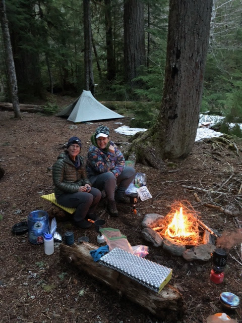
After 2.5 miles, you'll hit the Y that either goes left to eventually bring you to Enchanted Valley, or right towards Hayden Pass. We went left, but only to get us to the Dose Forks Camp at 8.5 total for the day, where we had a permit to stay. REALLY nice camp, and we had the whole place to ourselves.
 |
| SO ready to get this dang duro log out of my pack! |
 |
| But SO worth it! |
Day 2: Left camp and "slackpacked" back up to the Y, this time heading towards the PNT intersection, which you hit after a mile - mostly up. The grade after that is pretty gradual, but as mentioned, eventually got us up above the snowline. Pretty trail though, with one very beautiful waterfall. We got back to camp around 3:30, after an up and back total of 8 miles.
 |
Finally on the PNT
|
Day 3: Slogged the 8.5 miles back to the car, which was not as much fun in the rain. But a stop at Quilbilly's in Quilcene is a great way to dry out and warm up. Highly recommended! |
| A moody day out |
 |
A wet visit to the old Ranger Station
|
 |
A good beer makes everything better
|